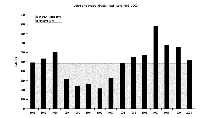
Several years ago, Gerald Berthold from Chemnitz suspected that the halo activity was subject to a certain periodicity.
What caused these seemingly periodic fluctuations, however, was a mystery for a long time. Solar activity was soon ruled out as the cause, as no similarities in the curves of halo and solar activity are evident.
It was more logical to look for the cause in the local weather kitchen - over the Atlantic. Perhaps the most important pressure formations for us in the northern Atlantic are the Azores High and the Icelandic Low. Although they are not always in their place, if you take long-term averages of air pressure, you can locate both well. And they have something else in common: at times when the Icelandic Low is particularly pronounced, the Azores High usually is too. Conversely, weak low pressure over Iceland is usually only associated with a moderate high west of Gibraltar. Like a kind of oscillation, some years show strong highs and strong lows, others weak highs and weak lows. This connection between the two pressure formations is known as the North Atlantic Oscillation (NAO). It is of considerable importance for the weather across the North Atlantic region and beyond. The NAO Index indicates the expression of the pressure difference: A high index thus means a strong Icelandic Low and a strong Azores High.
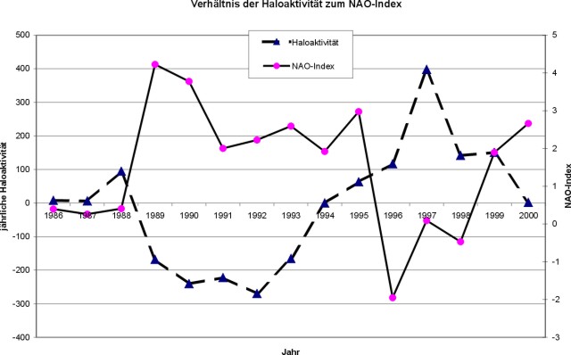
The NAO Index changes from year to year. Over longer periods, distinctly negative and positive phases can be seen, whose durations are similar to the individual periods in the halo activity curve. Of course, one cannot derive completely certain statements from a 15-year series, but I think the connection can be clearly seen in the following graphic. I have set the NAO Index in relation to the deviation of halo activity from the long-term average:
Some of the immediate effects of the NAO seem relatively easy to understand at first glance. For example, at a high NAO index, the surface water temperature south of Greenland is significantly lowered. Here, the Icelandic low seems to produce north winds that significantly lower the water temperature in the Labrador basin through Greenlandic polar air. Convection (sinking of water into the depths) slows down as a result, and less warm water flows from the Gulf region. The result would be lower temperatures in Central Europe as well.
Conversely, when the NAO index values are high, the water temperatures in the Bay of Biscay, the North, and the Baltic Seas clearly rise. If there is a strong air pressure difference between Lisbon and Reykjavik, the west-east air currents are also particularly strong, bringing slightly warmer and more humid sea air from subtropical regions to Central Europe. So, there are ideal conditions for the formation of cirrus clouds and ultimately halos, one might think. But particularly in such weather conditions, halo activity is especially low. And that's where the questions begin. Are there better halos with small pressure differences because the cirrus clouds of the lows can pass through unhindered at high altitudes? Or do even smaller lows create ice crystals with better optical properties? Under what conditions do different ice crystals form at all? Are halo phenomena predictable based on NAO forecasts? There is certainly a lot of research to be done in this area, and perhaps the aforementioned hypothesis is an incentive for the meteorologists among us to tackle these questions.
Links:
by Claudia Hinz

